UC Innovation Centre, Building
22 University Drive South Bruce,
ACT, 2617, Australia
CRC Freshwater Ecology

The CRC for Freshwater Ecology ceased operations in September 2005. This website is for archival purposes and is no longer updated.
CRC Catchment Hydrology

The CRC for Catchment Hydrology ceased operations in September 2005
Bushfire and Catchments website

This was developed to bring together information about effects of bushfire on catchments and the water resources they collect. This website is for archival purposes and is no longer updated
Drought Science website

Intended as a hub, bringing together information and links on the ecology, climate science and hydrology of drought in south-eastern Australian water catchments. The content is general, with pointers to further reading and resources. This website is for archival purposes and is no longer updated
H20 Thinking
A water management magazine covering useful information on research, environmental and water issues, as well as eWater activities.
Australia has a long and proud history of supporting water resource management in the Mekong region.
eWater Group’s three divisions – eWater Solutions, Australian Water Partnership, and Mekong Water Solutions – play a critical role in sharing Australia’s technology and helping to build capabilities in the region.
Australia has been a partner of the Mekong River Commission (MRC) since its inception in 1995. The MRC is an intergovernmental organisation, established “to help the lower Mekong countries build consensus around solutions that ensure a sustainable future for the Mekong and its people through basin monitoring, assessment, data and information sharing, and dialogue and cooperation.”
Since 2013, eWater Group has supported the Vientiane-based MRC and its four member countries (Cambodia, Laos, Thailand, and Vietnam) to enhance the management of the Mekong River’s water for the benefit of all who depend on it.
So how do we support the MRC?
Through the Australian Water Partnership, Australia has mobilised assistance on a range of strategically important issues including sustainable hydropower, regional flood and drought management, and management of fisheries in the rapidly developing river. Several Australian organisations are involved in delivering technical and capacity development support as part of Australia’s long-standing partnership.
Through eWater Solutions, we have helped the MRC to increase their understanding of inflows into the river and the impacts of dams in the river basin on flow levels and sediment transportation through our flagship software product, eWater Source. This world-class science and technology platform is playing a key role in delivering several elements of the MRC 2021-2025 Strategic Plan, including the report on low flow and drought conditions in 2019-2021, the Joint Study between MRC and Lancang-Mekong Cooperation Water Centre on Changing Pattern of Hydrological Conditions in the Lancang-Mekong River Basin and enhancements to the MRC’s Flood/Drought webpage to better integrate data and communicate vital information on river flows.
For our Solutions team, recent activities have included:
- advice on quality control procedures for incorporating hydromet (water and meteorology) data into MRC systems, to better inform day-to-day operations and provide faster response times;
- advice on the implementation of the MRC Procedures for data, water use and flow monitoring;
- supporting the initiative of the MRC Document Management System to ensure experience and knowledge from the past informs future planning;
- contributing to the report on low flow and drought conditions in 2019-2021, which was well received by international stakeholders;
- upgrading the Mekong Source model to incorporate new information, such as the storage strategies of reservoirs, in preparation for the Joint Study between MRC and Lancang-Mekong Cooperation Water Centre on Changing Pattern of Hydrological Conditions in the Lancang-Mekong River Basin;
- coordinating and consolidating technical inputs from both the MRC and Lancang-Mekong Cooperation Water Centre team members into the report of the Joint study;
- enhancing the MRC’s Flood/Drought webpage to better integrate data and communicate vital information on river flows.
According to eWater Group’s Principal Hydrologist and Mekong Team Leader, Dr Paradis Someth, “the success of eWater’s involvement with the MRC has been due to visionary leadership and trust of both parties and our work being clearly and directly aligned with the MRC Strategic Plan, which has ensured support from across the MRC Secretariat and relevant stakeholders.”
“Our collaborative partnership, with its strong focus on advice and coaching for staff in MRCS and member countries, has helped to develop the necessary skills and expertise to improve management of the Mekong River,” Dr Someth said.
For Australian Water Partnership General Manager, Sarah Ransom, “the long-term partnership with the Mekong River Commission represents shared trust with one another, and a shared interest in sustainable management and development of water resources in the Mekong basin. We look forward to continuing our support in the region.”
Over this period, eWater has enjoyed close working relations with the MRC Secretariat Leadership team and DFAT’s Mekong regional water team.
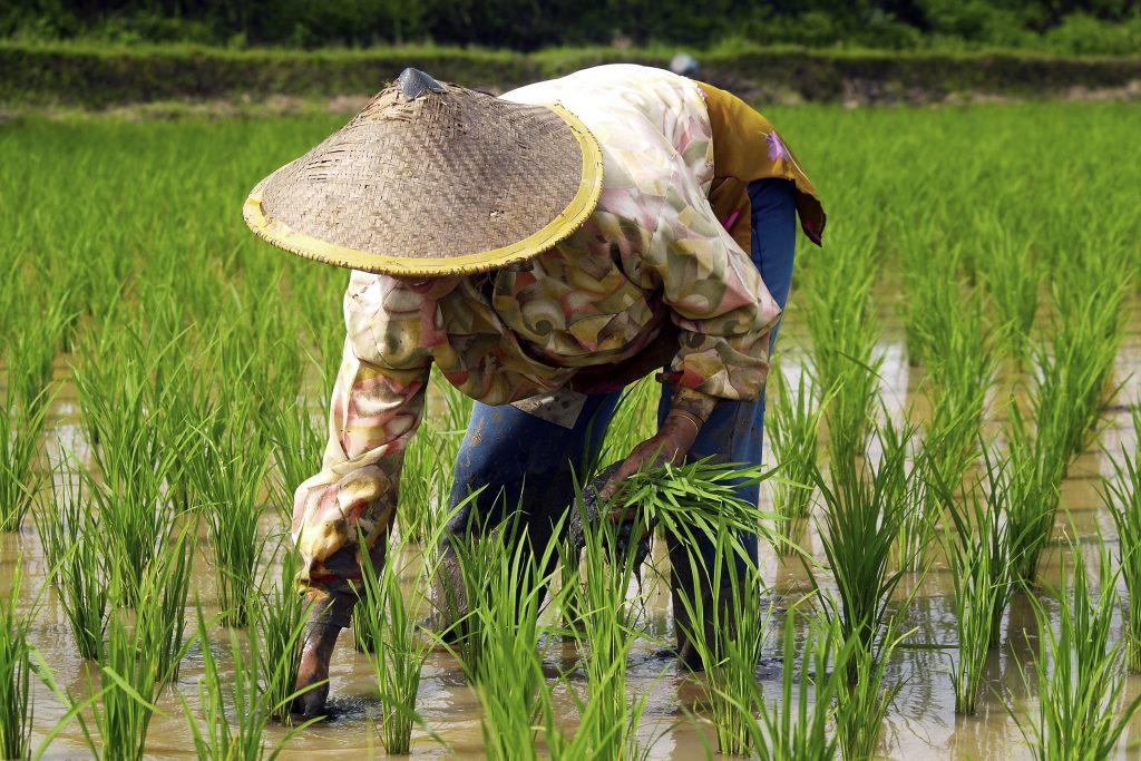
More than 300,000 people living in Stung Staung river basin in Northern Cambodia rely on agriculture for their livelihoods. Access to a clean water supply is fundamental for wellbeing and health particularly to prevent transmission of the COVID-19 virus. Increased food security, higher income for farmers and improved health in the villages can be expected if the reliability and quality of water supplies in the province can be enhanced through improved sharing of existing water supplies.
Partnering with the World Bank and support from the Royal Government of Cambodia (RGC), eWater undertook a study to assess the challenges of water supply development and to establish an enabling environment, based on scientific evidence, for a water sharing dialogue between authorities, farmers and relevant water users and assist with developing a long-term investment plan for water supply utility for Staung district in Kompong Thom Province.
Study Area
The Stung Staung river rises in the mountains of Northern Cambodia before flowing 213 km to the iconic Lake Tonle Sap, one of the largest freshwater lakes in the world. In its northern reaches, the river flows through forest before entering expansive cropland to the south. The majority of the 217 villages in the catchment are along the river in the farming districts which cover about a third of the catchment. More than a quarter of the people in the river basin live in poverty.
Competition between irrigation and village water supplies is increasing as climate change varies the annual rainfall pattern. Barrage ‘Samsep Kagna’ of 7,200 ha is the only large irrigation scheme in the catchment. Other existing schemes include 17 medium schemes and 8 small schemes (Figure 1). Currently, rainfed paddy rice is the main crop in the command areas, but further downstream field and garden crops are more common.
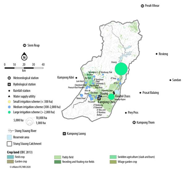
Figure 1: Irrigation schemes and water supply utility in the Stung Staung Catchment.
To help manage the water competition and cope with climate change, a large water reservoir of the Staung Water Resource Development Project with a potential area of 30,000 ha is planned.
Clean water supply in the coverage areas comes from the Stung Staung River, supplemented with groundwater from a 200m deep tube well next to the treatment plant near the river. A World Bank’s Water Supply and Sanitation Improvement Project (WaSSIP) aims to increase water supplies to villages by up to four times through a new water supply utility near Barrage ‘Samsep Kagna’.
Development of a Source model to assess demand and supply
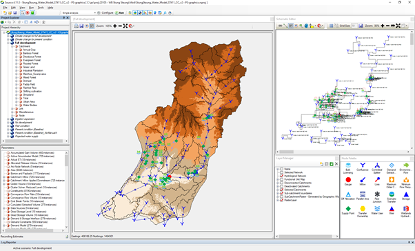
Through 2019-2020, funded by the World Bank, eWater, in collaboration with the Institute of Technology Cambodia (ITC) and Ministry of Water Resources and Meteorology (MOWRAM), and Ministry of Industry, Science, Technology and Innovation (MISTI) undertook a comprehensive catchment assessment in the Stung Staung River and developed a Source model to support dialogue on a water sharing plan in the catchment. The outcome of the assessment will support the design of future water supply infrastructure and investment potential of the RGC and the World Bank in Staung district.
Methodology
The data review included demography, geography, water sources, status and trends of water supply and demand, initial potential risks and mitigation measures. Additional hydrometeorological datasets were collected to help refine the existing country-wide Source model to form the Source Stung Staung Model, the model supports hydrological and water system modelling. The hydrological model was used to undertake a water balance assessment that characterised the natural condition (rainfall-runoff process) in the catchment. The water system model was run to quantify water demand from various sectors, mainly irrigation activities and municipal water requirements.
Once the hydrological characteristics for the catchment were defined, several future scenarios were formulated and later assessed using well calibrated models of the pre-development and future-development scenarios. This allowed for an assessment of potential hydrological risks. The simulations quantified surface water availability from the natural processes of rainfall-runoff and water resource use by different sectors. Hydrological baseline statistics were developed, which characterised the water supply/demand balance on a monthly, seasonal and annual basis.
Climate change impacts
An analysis of rainfall patterns over the Stung Staung Catchment reveals an observed change in rainfall between the past condition (2000-2011) and the present condition (2012-2019). The pattern of mono-modal with a peak in September has changed to bi-modal with peaks in July and September. A decrease in rainfall in August was clearly observed for all the key stations. Particularly, a big change in rainfall was observed at Stoung in the lower section of the river. Monthly rainfall in the wet season dropped about 100 mm. A significant drop was in September: decreasing from about 400 mm to below 200 mm. The climate change assessments suggest a decrease in all flow ranges from the present condition.
Pathway to resilient water resources
The project allows the Cambodian authorities to consider the developed workflow and application of the Source Modelling Platform for water balance analysis and catchment assessment as a scientific tool to support water allocation mechanisms.
The study recommended, through community discussions, establishing a minimum requirement for water quantity and quality as the priority for domestic water supply. Understanding community priorities will assist the large water storage managers in developing an equitable water sharing plan for domestic and irrigation water. While there is a potential for expansion of irrigation scale, the irrigation modernisation should be taken into account of water balance to improve the sustainability of the irrigation system, providing benefits to farmers and the downstream biodiversity and aquatic environment in the river. Crop intensification would lead to higher irrigation water demand resulting in water shortage so shifting the crop growing calendar could be considered as a way to ease water shortages in May and June.
With signs of less water available in the future, the villages in the river basin need to discuss their options, such as crop diversification to high value crops, which may generate greater income with less water. The study provides valuable details and guidance for the authorities and villagers in the river basin to mitigate risks and for Development Partners to investigate water resource development option and enhance water resource management benefits in the Stung Staung Basin.
Related information
Read this article by the CAVAC (Cambodia-Australia Agricultural Value Chain Program) for more on the use of water models in Cambodia https://cavackh.org/public/post/using-water-simulation-models-to-support-sustainable-water-resources-management
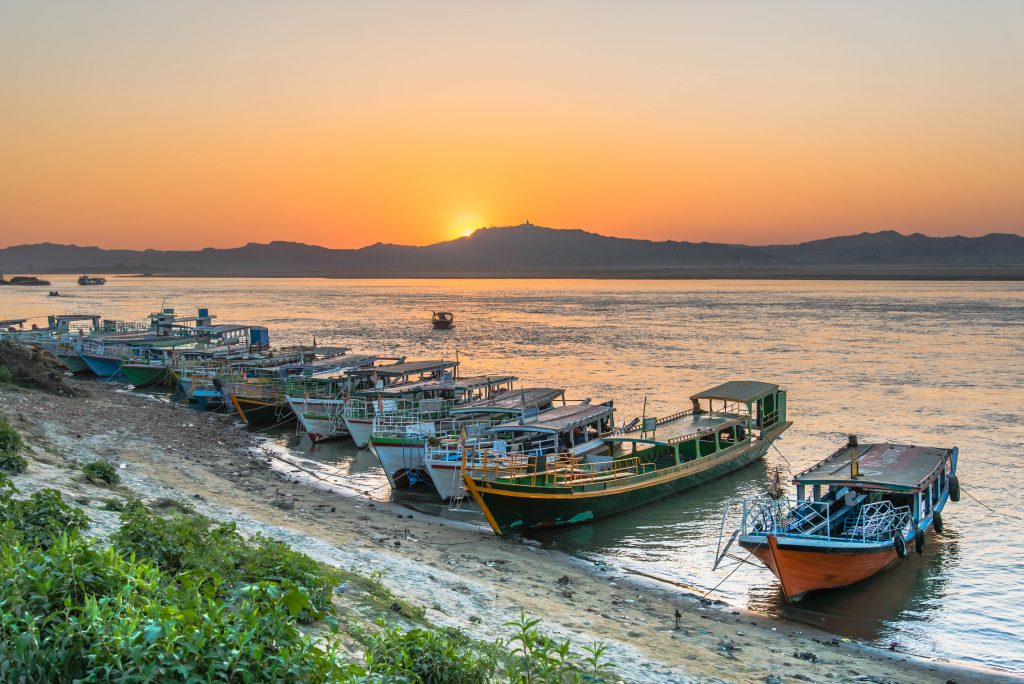
The Ayeyarwady River is Myanmar’s largest and most commercially important river but its water resources are not well understood.
With the support of the Australian Water Partnership, the Government of the Republic of the Union of Myanmar commissioned the first integrated assessment of the natural resources of the Ayeyarwady Basin. eWater lead the surface water assessment for the State of the Basin Assessment (SOBA).
The Ayeyarwady Basin
With an area of just over 675 000 km2, the Republic of the Union of Myanmar is the second largest country in South-East Asia, after Indonesia.
The Ayeyarwady River starts in the Himalayas, flowing for approximately 2 000 km in a north-south direction through Central Myanmar. The river basin has a total area of 413,700 km2 and covers about 61% of Myanmar. About 5% of the Basin extends into the neighbouring countries of India (to the west) and China (to the east).
The Ayeyarwady River Basin is dominated by a monsoonal rainfall regime, associated with the south-western Indian monsoon. It is also affected by convectional systems and cyclones from the Bay of Bengal. Groundwater flows to the streams and snowmelt from the northern regions are also important contributions to basin flows.
The Ayeyarwady River Basin is still a relatively undeveloped basin. Like the majority of Myanmar, most of the Basin is characterized as rural, with agriculture the main use of water.
Project overview
The SOBA provides a baseline assessment of the basin’s water and other natural resources, from which future management options can be compared against.
eWater developed a preliminary baseline Source water system model for the Ayeyarwady Basin (north of the delta), from which a baseline assessment of the basin’s surface water resources was undertaken.
The model is run with historic climate data for 1982 to 2016, land use in 2014 and storage capacity in 2016. It represents agriculture, domestic, urban and hydropower water use.
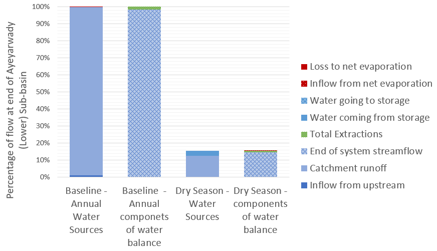
For the first time, the baseline assessment gives water managers a description of the hydrology of the Ayeyarwady River Basin according to 5 Hydro-Ecological Zones and 13 sub-basins, significantly increasing the understanding of both water availability and water use in the basin. For example, in the figure below, we can see the different components that contribute to flow at the end of the system as an annual total and during the critical dry season, it shows how much water is provided by different sources and how much of this water is used or lost to evaporation.
The water system model is a first cut at drawing together the information required to adequately understand and simulate the complexities of the Ayeyarwady River Basin. The baseline model will be a key tool to support the future management of the basin’s water resources, making it possible to:
- Combine outputs from the model together with observed values, to provide an overall assessment of water availability and uses across the Ayeyarwady River Basin.
- Understand baseline water availability and use, to support the ongoing assessment of the Basin’s water resources and to examine possible future scenarios and possible implications, for example with climate change or increased agricultural use.
- Simulate components of the hydrological cycle at locations where observed values are not available.
- Identify information gaps and inform future data collection initiatives.
Scoping Study
Following the completion of the SOBA, eWater was engaged to undertake a scoping study of potential development options for the mainstream of the Ayeyarwady River and tributary flows. The study was also supported by the Australian Water Partnership.
The scoping study sought to demonstrate how water resource models can be used to assess management scenarios and provide valuable outputs to support stakeholder consultation.
The surface water system model was adapted to allow it to provide information on the likely changes in the Ayeyarwady mainstream and tributaries from different development scenarios. The scoping model can assess the likely flow changes from different development options, to consider the impact on water dependent outcomes such as irrigation, hydropower production, surface water flow heights and and flood magnitude. It is not intended to evaluate specific development proposals.
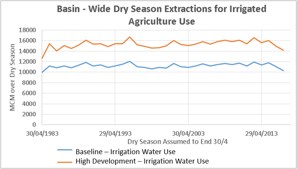
The scoping model was used to compare a High Development Scenario of hydropower on the tributaries and some irrigation development in the Central Dry Zone against a baseline scenario. The baseline scenario included ‘current’ irrigation demand and hydropower dams representing 2000 megawatts of hydropower, it does not include some 30 irrigation storages where data was not available.
The results compared include:
- Change in hydropower generation on an annual and seasonal basis, inter-annual variability was also assessed.
- Agriculture water use and availability assessed on an annual and inter-annual basis.
- An assessment of changes to hydrographs at Sagaing, Pyay and Monywa, including changes in flow volume as well as surface water level.
An example of the scoping model outputs is shown below. In this, dry season irrigation extraction under the baseline and high development scenarios are compared.
Capacity Building
eWater conducted face to face training programs to introduce water managers in Myanmar to the principles of hydrological modelling and the use of Source. The training used the new Ayeyarwady Source model, providing participants with hands-on experience in the use of the model.